Maps Scale Drawings and Bearings for the ESAT
Updated July 2026
This guide covers the interpretation of maps and scale drawings alongside the use of three-figure bearings. You will learn to calculate scale ratios, measure directions clockwise from North, and apply geometric and trigonometric principles to solve navigation problems within the ESAT Mathematics 1 syllabus.
A scale drawing is a proportional representation of an object using a specific ratio, while a three-figure bearing is a directional angle measured clockwise from North and expressed as a three-digit number.
Maps and scale drawings
A scale drawing is an enlargement or reduction of an original object, typically involving a fractional scale factor. When interpreting these drawings, it is essential to maintain consistent units to find the scale factor accurately. For example, if a circle in a real-world setting has a radius of 2 m and is represented on a scale drawing with a radius of 10 cm, we can find the scale factor by converting both to the same unit. Since 2 m is equal to 200 cm, the scale factor of the enlargement from the drawing to the real world is . This relationship can be expressed as a ratio of 1 : 20 or stated as 10 cm representing 2 m.
A map is a specific type of scale drawing that provides a two-dimensional, aerial view or plan of a landscape.
Bearings
Bearings are a standardised method for describing the direction of one point from another. There are three fundamental rules for three-figure bearings:
- They are always measured clockwise.
- They are always measured from the North line.
- They are always written as a three-digit number.
For instance, a direction that is 50° clockwise from North must be written as 050°. To determine the bearing of a point P from a point Q, you must first draw a North line at point Q, which is the point where the measurement starts. North lines are always drawn vertically towards the top of the page. You then connect Q to P and measure the clockwise angle between the North line and the line segment QP.
To find the reciprocal direction, or the bearing of point Q from point P, you draw a North line at P, connect P to Q, and measure the clockwise angle from the North line at P to the line segment PQ.
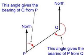
Many problems involving maps and bearings can be solved through a combination of scale drawing, geometric rules, or trigonometry.
Example: Calculating map scale
A map includes two villages, Riverside and Hilltop. The actual distance between the village shop in Riverside and the post office in Hilltop is 2 km. On the map, this distance is measured as 8 cm. To find the scale in the form 1 : n, we first convert the actual distance into centimetres:
The scale ratio is . By dividing both sides by 8, we simplify the ratio:
Example: Calculating back bearings
Suppose the bearing of point B from point A is 070°. To find the bearing of point A from point B, we follow these steps:
- Draw point A and a North line.
- Draw a line at 70° clockwise from North and mark point B.
- Draw a North line at B. Since both North lines are parallel, we can use the property of interior angles.
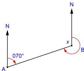
Let be the angle between the North line at B and the line segment BA, measured anticlockwise. Because the North lines are parallel, , so . The bearing is the clockwise angle from North, which is .
Bearings and geometry
Sometimes, bearing problems involve distances that create specific geometric shapes. Consider a ship S which is 10 km from a lighthouse L on a bearing of 120°. A yacht Y is also 10 km from S, and the bearing of Y from S is 250°. We want to find the bearing of Y from L.
Since the distances LS and SY are both 10 km, the triangle LSY is an isosceles triangle. To find the bearing, we first need the internal angle LSY.
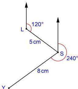
First, we find the angle between the North line at S and the line SL. Using parallel line properties, the angle is . Then, we can find angle LSY by looking at the full 360° rotation at point S: Angle .
In the isosceles triangle, the remaining angles SLY and SYL are equal: Angle .
The bearing of Y from L is the original bearing of S from L plus the internal angle SLY: Bearing = .
Bearings and trigonometry
Trigonometry is useful when bearings result in right-angled triangles. For example, point X is 10 km from Z on a bearing of 060°. Point Y is due North of Z and is on a bearing of 270° from X (meaning X is due East of Y). We need to find the exact distance XY.
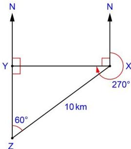
In this arrangement, angle ZYX is 90° because Y is North of Z and X is East of Y. The angle at Z is 60°. We can use the sine ratio:
Substituting the known values:
Key takeaways
- Bearings must always be written as three digits, adding a leading zero for angles less than 100 degrees.
- All bearings are measured clockwise from the North line, which is represented as a vertical line pointing up the page.
- To calculate scale ratios like 1 : n, both the map distance and the real distance must be converted to the same units before simplifying.
- The relationship between the bearing of B from A and A from B relies on parallel line properties, where interior angles sum to 180 degrees.
Always draw a clear, large sketch for bearing problems. Do not worry about drawing it perfectly to scale, but ensure the North lines are parallel and the clockwise direction is clearly marked to avoid simple calculation errors.
A common error is measuring the angle anticlockwise from North or clockwise from a horizontal line. Always re-check that your measurement starts from the vertical North line.
The concept of the 'back bearing' is mathematically equivalent to adding 180 degrees to the original bearing if it is less than 180, or subtracting 180 if it is greater. This stems from the geometric property of alternate and interior angles between parallel North lines.
Frequently asked questions
What happens if I forget to write a bearing as three digits?
In the context of the ESAT and professional navigation, accuracy is vital. A bearing of 70 degrees must be recorded as 070 to avoid confusion with other types of coordinate or angular measurements.
How do I know whether to use geometry or trigonometry for a bearing problem?
If the problem involves equal distances, look for isosceles or equilateral triangles. If the problem involves 'due North' or 'due East' directions, it often creates right-angled triangles where can be applied.
How do I convert a scale like 1 : 50,000 into useful distances?
The ratio 1 : 50,000 means that 1 unit on the map equals 50,000 of the same units in reality. For example, 1 cm on the map represents 50,000 cm (or 500 m, or 0.5 km) in the real world.